travel
Where Is Punta Cana? Your Complete Location Guide
You have seen the photos. Impossibly white sand, water so blue it looks digitally enhanced, palm trees leaning toward the horizon at just the right angle. And somewhere in the caption, the words: Punta Cana. But if you have ever stopped and thought, “Wait, where exactly is that?” you are far from alone. For one of the most visited destinations in the entire Caribbean, Punta Cana confuses a surprising number of travelers about its precise location before they book their tickets.
Let’s fix that. This guide covers everything you need to know about Punta Cana’s location on the map, which country it belongs to, how its geography shapes your experience, and what you will find when you get there.
Punta Cana Is in the Dominican Republic
First things first. Punta Cana is located in the Dominican Republic, a country occupying the eastern two-thirds of the island of Hispaniola in the Caribbean Sea. This is a point worth making clearly because a genuinely large number of people assume Punta Cana is in Mexico, Cuba, or some vaguely tropical country they cannot quite name. It is none of those places. It is firmly in the Dominican Republic, one of the most geographically diverse and culturally rich nations in the Caribbean.
Hispaniola itself is the second-largest island in the Caribbean, shared between two nations: the Dominican Republic to the east and Haiti to the west. The Dominican Republic claims roughly 48,440 square kilometers of that island, about the same size as the Netherlands. It is a country that stretches from tropical beaches to mountain ranges, and its highest peak, Pico Duarte, rises to about 3,000 meters above sea level, making it the tallest mountain in the entire Caribbean. The same country that gives you those palm-lined resort beaches also has cloud forests, colonial cities, and rivers running through national parks.
Punta Cana sits in the province of La Altagracia, the easternmost province in the Dominican Republic. The provincial capital is the city of Higüey, a historically significant town known across the country for the Basilica of Our Lady of Altagracia, a major Catholic pilgrimage site. Administratively, the Punta Cana area was formally recognized as the Verón-Punta Cana Touristic Municipal District in 2006.
The Geography: Where Two Oceans Meet
Here is the geographical detail that surprises most people. Punta Cana sits precisely at the point where the Atlantic Ocean and the Caribbean Sea converge. The eastern tip of Hispaniola is where these two bodies of water meet, and that meeting point is not just a fun fact for geography enthusiasts. It directly shapes the character of the beaches, water temperatures, marine life, and wave patterns you experience throughout the region.
The Atlantic-facing beaches tend to have slightly stronger swells and more dynamic surf conditions. Macao Beach, beloved by surfers and bodyboarders, is a good example of this Atlantic energy. The Caribbean-facing and more sheltered stretches, like the famous Bávaro Beach, tend to offer calmer, crystal-clear waters in that turquoise shade that fills every travel brochure. Swimming conditions there are gentler and generally ideal for families and those who prefer a more peaceful ocean experience.
This dual-ocean character also supports exceptional marine biodiversity. The surrounding waters were declared a marine reserve in 2012, and the area is home to coral reefs, tropical fish, sea turtles, and a wide range of underwater life, making snorkeling and scuba diving consistently rewarding.
What “Punta Cana” Actually Means
The name itself is worth unpacking, as it reveals something about the place. “Punta” is the Spanish Word for “point” or “tip,” and it refers to the easternmost point of the country’s mainland. “Cana” traces back to indigenous Taíno language roots, with interpretations that connect it to golden palm trees or pristine natural land. Together, the name essentially describes a pointed headland lined with palms, which is about as accurate a description of the landscape as a place name can get.
When travelers say “Punta Cana,” they are usually referring to a much broader coastal region than the specific small settlement near the airport that technically carries the name. Over the years, “Punta Cana” has become the widely used umbrella term for the entire eastern resort zone, encompassing several distinct areas that each have their own character.
The Sub-Regions That Make Up Greater Punta Cana
Understanding the layout of the Punta Cana region helps enormously when choosing where to stay and what to expect. The greater Punta Cana area stretches along roughly 50 kilometers of coastline and includes several neighborhoods and zones.
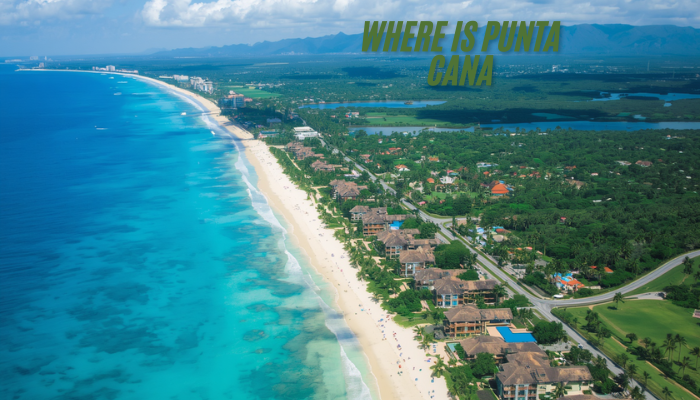
Bávaro is the heart of the resort corridor and where most first-time visitors end up. It holds the highest concentration of all-inclusive resorts and is generally considered the most accessible and well-developed part of the region. Bávaro Beach itself is one of the most photographed beaches in the Caribbean, and the area is buzzing with shops, restaurants, entertainment venues, and the logistical support that mass tourism requires.
Cap Cana is the upscale, gated development on the southern end of the eastern coast. Spread over more than 6,000 acres, Cap Cana is home to luxury resorts, private villas, a world-class marina, and the renowned Punta Espada golf course. It has its own ecosystem of high-end amenities and attracts travelers seeking a quieter, more exclusive experience than the busier resort strips further north.
Macao sits further up the coast and retains a more natural, less commercialized feel. It is the beach of choice for surfers and those seeking something beyond the resort atmosphere.
Uvero Alto is at the northern end of the tourist zone, quieter still, and appeals to travelers who want beach access without the crowds that gather around the main resort corridors.
How Far Is Punta Cana from Major Cities?
One practical question travelers always want answered is how long it takes to get somewhere from the airport or from various points on the island. Here is a helpful frame of reference.
The Punta Cana International Airport (IATA code: PUJ) sits roughly three kilometers inland from the coastline, and most resorts are between 10 and 35 minutes away by road. The airport is not only the busiest in the Dominican Republic but also one of the most active in the entire Caribbean, handling around 64% of all international arrivals into the country. Notably, it was the first privately owned international airport in the Western Hemisphere when it opened in 1984, built by the same development group that created the region’s tourism infrastructure.
From Punta Cana, the capital city of Santo Domingo is approximately 2.5 hours by road along the Oscar de la Renta Highway, also known as the Coral Highway. That drive takes you through the island’s interior and offers a very different picture of Dominican life than the resort zone does. La Romana, another coastal town known for Altos de Chavón and access to Isla Catalina and Isla Saona, is about an hour to the southwest. The city of Higüey, the provincial capital and closest major inland city, is around 45 minutes away.
Day trips from Punta Cana to destinations like Saona Island, Los Haitises National Park in Samaná, and the colonial streets of Santo Domingo are all genuinely feasible for visitors who want to see more of the country than their resort grounds.
How to Get to Punta Cana
Getting to Punta Cana is straightforward compared to many Caribbean destinations, which is part of why it has grown so dramatically as a travel hub. Direct flights connect Punta Cana to cities across North America, Europe, South America, and beyond. The airport receives flights from more than 26 countries, and from many major North American cities. The flight is between three and five hours. This accessibility, combined with the prevalence of all-inclusive packages that make budgeting simple, goes a long way toward explaining why Punta Cana welcomed over 4 million visitors in 2024 alone and ranks as the second most popular tourist destination in Latin America.
Since 2017, cruise passengers have also been able to arrive directly at Marina Cap Cana, which now accommodates smaller luxury cruise ships, adding yet another access point for travelers arriving by sea.
Climate and the Best Time to Visit
Punta Cana’s position on the eastern tip of the island gives it a tropical wet-and-dry climate that remains reliably warm year-round. Average temperatures hover around 26 degrees Celsius (roughly 79 degrees Fahrenheit) year-round, making any month theoretically a good time to visit.
The drier, cooler season runs from November through March. Evenings during this period can dip to around 20 degrees Celsius, making outdoor dining and beach walks comfortable and pleasant. This is considered the peak tourist season, and prices reflect that. The hotter, more humid season stretches from May through October, with daytime temperatures occasionally reaching 35 degrees Celsius. This period overlaps with the Atlantic hurricane season, which runs from June through November, though direct hurricane hits on Punta Cana are relatively infrequent compared to some other Caribbean destinations.
For travelers who want reliable sunshine, reasonable prices, and comfortable heat without oppressive humidity, the shoulder months of April, early May, and late October can offer a genuinely good balance.
What the Coastline Offers Beyond the Beach
It would be easy to describe Punta Cana as simply a beach destination and leave it there. The beaches are extraordinary. Bávaro in particular is consistently cited among the finest beaches in the world, and the quality of the water along most of the 50-kilometer Coconut Coast is hard to overstate. But the appeal of the location extends further.
The marine reserve surrounding the area supports one of the longest coral reefs in the world, approximately 31 kilometers long, providing exceptional conditions for snorkeling and scuba diving. Watersports of every variety are available along the coast, from windsurfing and kitesurfing to deep-sea fishing, catamaran sailing, and swimming with stingrays in designated natural settings.
Inland, the landscape shifts from beach resort to Dominican countryside. Plantations, rural communities, gentle mountain terrain, and natural parks give visitors a completely different experience of the eastern part of the island if they choose to explore beyond the hotel zone.
The Puntacana Foundation maintains a private ecological reserve covering over 1,500 acres that serves as a research base and sanctuary for native and endangered species. The same development that built one of the Caribbean’s largest resort zones also embedded a genuine conservation effort, adding an interesting dimension to the destination’s identity.
A Destination Built Almost From Scratch
One fact that puts Punta Cana’s geography in perspective is that the entire tourism infrastructure was created only recently. In the late 1960s, the land that is now Punta Cana was largely undeveloped coastal terrain accessible only via a five-hour drive from the nearest city. A small group of investors, including Dominican entrepreneur Frank Rainieri and American attorney Theodore Kheel, saw potential in the location after aerial photographs revealed the coastline.
Their first project was a 40-guest hotel. Within a few decades, that small property grew into one of the most extensive resort corridors in the Caribbean. A destination that did not meaningfully exist as a tourist zone fifty years ago now hosts millions of visitors annually and handles the majority of international air arrivals for an entire country. That trajectory is almost without parallel in Caribbean tourism history, and it happened because of geography. The location, the two-ocean setting, the climate, the coastline, the accessibility by air: all of it was already there, waiting for someone to arrive and build around it.
Why the Location Matters to Your Trip
All of this geographical context is not just academic. Knowing where Punta Cana sits shapes practical decisions about your trip. It tells you which airports offer direct flights and roughly how long your journey will be. It explains why some beaches have calm water and others have waves. It helps you understand what day trips are realistically within reach without sacrificing an entire day in transit. It clarifies why the climate is so consistent and why the marine life is so varied. And it contextualizes the broader country you are visiting, one with mountains, cities, and history far beyond the resort strip you are staying on.
Punta Cana is in the Dominican Republic, on the eastern tip of Hispaniola, where the Atlantic and the Caribbean meet. It is warm, accessible, and built around one of the finest stretches of coastline in the entire region. Now you know exactly where it is, and you are better prepared for everything that comes next.


The Wakizashi: Japan’s Essential Short Sword Explained

Where Is Punta Cana? Your Complete Location Guide

Jablje: Slovenia’s Renaissance Jewel With Roots in Apple Trees
-

 Fashion9 years ago
These ’90s fashion trends are making a comeback in 2017
-
Entertainment9 years ago
The final 6 ‘Game of Thrones’ episodes might feel like a full season
-
Fashion9 years ago
According to Dior Couture, this taboo fashion accessory is back
-
Entertainment9 years ago
The old and New Edition cast comes together to perform
-
Sports9 years ago
Phillies’ Aaron Altherr makes mind-boggling barehanded play
-
Business9 years ago
Uber and Lyft are finally available in all of New York State
-
Entertainment9 years ago
Disney’s live-action Aladdin finally finds its stars
-
Sports9 years ago
Steph Curry finally got the contract he deserves from the Warriors